By ROBERT JUMPER
Tutiyi (Snowbird) and Clyde, N.C.
There is a place where if you want to know what the speed limit is, you must stop and clean the kudzu off the signs. There is a place where you must check the current date when you see an event sign to ensure that it is in the future or past, because promoters and billboard companies are not required to cover up stale messages. There is a place where political campaign signs are left in public view from one election to the next, even if the candidates aren’t in the running. There is a place that holds the title of a tourism destination, yet people routinely must stop and ask for directions to our leading attractions.
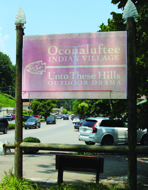
The old Indian Village/Unto These Hills sign that sits in the center of the cultural district resembles the style of the old arrowhead wayfinding signage. (ROBERT JUMPER/One Feather photos)
That place is the Qualla Boundary.
I have been asked several times over the years for directions to our casino. I’ll be walking down Tsali (sometimes across from the welcome center), and a tourist will stop and ask how to get there, or to the Village (Oconaluftee Indian Village), or even to the Museum of the Cherokee People and Qualla Arts and Crafts, even though those attractions are roadside and clearly visible. And we don’t even want to talk about Kituwah nor the Tribal Dispensary. I have even had people ask me where the Oconaluftee Island Park is, and they are standing only a few feet from it.
I found this on the Destination by Design marketing firm website: “Wayfinding signage is more than just pointing people in the right direction. It is a strategic tool for strengthening local economies. When thoughtfully designed and placed, signage can boost efficient traffic flow, extend visitor stays, highlight key assets, and promote local pride. At Destination by Design, we’ve seen communities thrive after investing in a well-planned signage system.”
I reached out to a few of the community leaders in the area to get some idea of how they see wayfinding signage affecting their community.
Todd Vineyard, executive director of the Jackson County Chamber of Commerce, said, “Wayfinding signage is one of the quiet engines of economic development. When visitors can easily navigate a community — find parking, locate shops, reach trailheads, and understand how districts connect — they stay longer, spend more, and explore more broadly. Clear, consistent wayfinding is also a public safety tool. When people know where they are, where they’re going, and how to get there, emergency response is faster, traffic confusion is reduced, and pedestrians make safer decisions. We’ve seen in places like Dillsboro how thoughtful wayfinding can reinforce a community’s identity. Their signage reflects the town’s character, guides visitors intuitively, and encourages exploration beyond the main corridor. It’s a great example of how small towns can use design to strengthen both commerce and community pride. In mountain communities like ours, where visitors often arrive unfamiliar with our geography, wayfinding isn’t just helpful — it’s essential. Good signage reduces frustration, improves the visitor experience, and supports the businesses and attractions that depend on tourism. Strategic wayfinding is one of the simplest investments a community can make with the highest return. It’s not just about signs; it’s about creating a welcoming, navigable environment that supports local businesses and helps visitors feel confident and connected.”
Nick Breedlove, executive director of the Jackson County Tourism Development Authority, shared his perspective on wayfinding. “Wayfinding signage is one of the first things a new visitor notices, and it’s a direct investment in how easy our communities are to explore. Good signage points traffic toward assets people might otherwise drive right past. Think about how a theme park or museum uses signs to pull guests into every corner. Community wayfinding works the same way, and the spending follows. A 2010 Asheville Convention & Visitors Bureau survey of 4,076 people found that 87 percent said they’d explore the city more if signage and kiosks pointed them toward additional attractions. And these signs help with safety too. Trying to navigate a crowded district while squinting at a phone or dash-mounted GPS creates distracted drivers and pedestrians. Big, visible physical signs keep eyes up and on the road.”
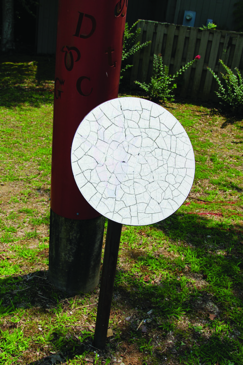
This sign is on a pathway through the Cultural District and was intended to lure visitors further into the cultural area with educational materials about the Cherokee Clans. All those signs now look like this, faded, unreadable, and cracked by weather and time.
It has been my experience that GPS (Global Positioning System) units do not always provide accurate directions in the mountains of western North Carolina, even when an address is provided to the application. If you have ever used satellite radio, you know that the signal gets lost frequently as the car’s satellite radio “antenna” loses contact with its satellites. The same happens with GPS units. And, as Todd and Nick said, wayfinding signage is much more than just a way to guide folks to their desired destination. It tells the community and traveler a little bit about the culture and pride of a place. All of us are overly dependent on our smartphones. And even smartphones make mistakes.
Once a traveler gets to your destination, wayfinding signage may be their first impression of you and your community. The signage program for a destination goes hand-in-hand with their strategy on curb appeal, another critical element in putting a community’s best foot forward. Successful destinations coordinate and lead the look and messaging of their signage, incorporating it into the overall marketing strategy.
One of the most successful tourism marketing campaigns in America is the “Pure Michigan” tourism effort. You may have seen a license plate or two with that logo. You see, the Pure Michigan look and message were so powerful that it was adopted by the state government and became the moniker for the state.
“In an effort to better plan and coordinate future tourism promotion activities, Travel Michigan, in coordination with the Michigan Economic Development Corporation, Travel Commission, and Michigan State University, released a five-year Michigan Tourism Strategic Plan in December 2012 (Ben Gielczyk, Senior Fiscal Analyst, House Fiscal Agency).”
Since its inception in 2006, the impact of Pure Michigan has grown exponentially. This, according to the State of Michigan, “The Pure Michigan campaign has been credited with generating billions of dollars in visitor spending and contributing significantly to Michigan’s economy over its two decades of operation. According to a 2024 report by Tourism Economics, the campaign influenced more than 789,000 leisure trips to Michigan from national, regional, and state markets, resulting in $1.3 billion in visitor spending. This spend directly supported over $79 million in state tax revenue (briefglance.com).”
According to Kelly Wolgamott, vice president of Pure Michigan (article by Sheldon Krause, “Pure Michigan campaign marks 20 years, generates billions in revenue,” April 9, 2026). “For every dollar we had within the campaign, $10.78 came back into the state.”
Attention to detail, like wayfinding signage, is critical to the success of marketing campaigns. The term “brand” is popular in marketing. So, can you really claim a resource as your own if you don’t brand it, literally and figuratively?
I asked the Asheville Chamber of Commerce to share their insights on the importance of wayfinding signage.
Ashley Greenstein, public information manager for Explore Asheville, said, “Strategic wayfinding is one of the most effective investments a community can make toward its visitor economy. Our network of more than 400 signs across Buncombe County points visitors to local attractions, shopping, and cultural districts, encouraging visitors to explore longer and extend their spending to surrounding towns like Black Mountain, Weaverville, and Woodfin. Results from other destinations informed our investment: Camden, New Jersey, saw a 30 percent rise in visitation, and Dallas’s Arts District grew its economic impact by 20 percent following its wayfinding rollout. A wayfinding system reinforces our community as a walkable, discoverable destination, weaving in local culture and history at every turn, so visitors feel equipped and inspired to explore it fully on foot and behind the wheel.”
Since the good old days of wooden arrowhead signage, which, to my knowledge, was the last concerted effort to execute uniform signage (and I think that was by accident because arrowheads were the “native” image at the time and the effort was the only one going on back then), signage on the Qualla Boundary has sprouted in every corner, and not necessarily to the benefit of our community.
I asked EBCI Commerce Secretary Sean Ross to share his thoughts on wayfinding signage on the Boundary. He had some encouraging updates about the ongoing efforts to revitalize signage on the Boundary.
“We are actively in the process of a signage audit and an active schedule of replacement.
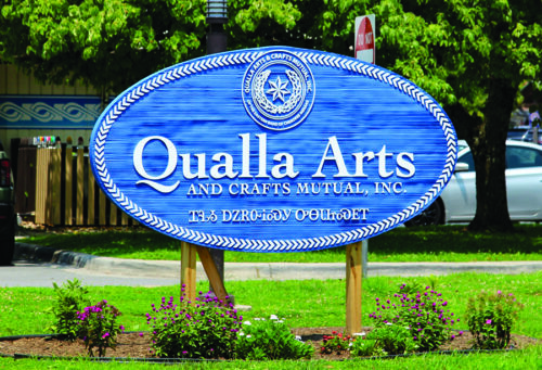
The refreshed Qualla Arts and Crafts Co-op signs are a “sign” of what the future could hold for wayfinding on the Qualla Boundary.
Our teams, consisting of Destination Marketing, Communications, and Project Management, along with our Agency of Record (French West Vaughn), have initiated a style guide and brand standard that we are incorporating into the look and feel of the signage replacements. Within marketing and advertising, via social media, print, and outdoor (billboard) messaging, there is a consistency of prominent placement of our syllabary over English wording, specifics concerning font type, color palette, font sizing, and stay-away space relative to logos and cultural icons. Using a strategic type of design and messaging framework, we plan to build the same elements within the replacement signage in and around the Qualla Boundary.
Some of the things you are beginning to see now began as a process a little over a year and a half ago, as we wanted to review some of the studies and consultation over the last 4 plus years (via charrettes, information gathering sessions and work groups consisting of business owners, elected officials, cultural partners and community members), being cognizant of those considerations as we moved forward with current strategies and augmentations based on new and historical feedback.
We have started with a complete outdoor board vinyl switch-out for our tourism boards, entertainment, events, and cultural-partner boards, and that look and feel has transitioned into some standardized retail signage for the outlets in the business district. To be clear, the signage has not been for directional function per se, but rather, signage resolute for monument, and informational/destination based.
Additionally, through assistance from the Etiquette Committee, we have designed and placed signage all along the boundary communicating to our visitors a step-by-step guide for appropriate use of public space, sensitivity to our culture, consideration of indigenous flora and fauna, as well as restricted areas of tribal land. The signage is clear, concise, and has recognizable icons for easy visual scanning and processability.
It is lost on none of our teams that there is a need for directional signage, and we have collaborated with consultants to lay down a framework for a comprehensive plan for design (congruent with established brand standards) and deployment. The process will have to be executed through an appropriate system of phasing relative to the established assets we have, newly added assets, and future assets as they come online. This process cannot be completed all in one fell swoop, as the overarching footprint or landscape will be one of constant shifts and movements within the next few years as the projects move progressively.”
In a political environment, the can sometimes gets kicked down the road, and it is out of any particular person or entity’s hands as to where and when the can lands. I know from serving decades in the businesses of product promotion and placement that getting consensus on things like uniform signage is tedious and time-consuming. But the economic potential should be assessed and communicated to the parties in power so that those parties understand the cost of delay. I am not sure if an analysis has been requested or performed, but if not, it should, and, if so, the findings should be shared with the entities and community.
As the late Ken Blankenship, former executive director of the Museum of the Cherokee People, was famous for saying in an entity meeting, “We have plenty of traffic from tourists coming through Cherokee. Our challenge isn’t that. It is getting people to pull into my parking lot.”
Ken’s comment always stuck with me as I served here on the Boundary and as I served in Jackson County as chairperson of the Jackson County Travel and Tourism Authority and, later, Tourism Development Authority. Our duty to the community doesn’t stop at getting guests to our destinations. We have to drive that visitor and their dollars through the front doors of our entities.
Most importantly, it is providing directional signage for the essential needs of all people, whether from inside or outside our community. Hypothetically, say you are a tribal member who has finally got that dream job on the Boundary. You have been waiting for years for something to open up in your field that would pay a living wage. You bring your family to your new home on Soco and start living life. Then, one day, a loved one is critically hurt, and your first instinct is to throw them in the car and rush them to the hospital. Yes, 911 should be our thought, but when a loved one is in dire need, we tend to get a little (a lot) impulsive. So, you try to rush your loved one to the hospital. Is there enough wayfinding signage to get you where you need to be? These are things we don’t think of over a normal day. Just like pedestrian crossings, safety is sometimes an afterthought.
Bill Paul, EBCI Safety Training Officer for Risk Management, said, “From a Risk Management point of view, wayfinding signage is much more than a convenience; it is a necessity that is critical for reducing accidents and injuries, improving traffic and pedestrian flow, and improving the visitor experience”.
The One Feather office is in the Ginger Lynn Welch Complex on Acquoni Road. For the last couple of years, there has been an ongoing effort by the EBCI Water and Sewer Department to dig up and replace the aging and overtaxed water and sewer pipes that run the length of Big Cove and Acquoni Roads. Currently, the project has a portion of the road completely shut down during the workday, requiring traffic to be routed onto Tsali Blvd. to access Acquoni from the Saunooke Village end of the road. Traffic, primarily tourist traffic but some local traffic, is having a difficult time navigating the road closure. This was discussed at the July 20 meeting of the Tribal Planning Board.
Tyler Blankenship, director of operations and public facilities, and Kolanvyi (Big Cove) Rep. Lavita Hill discussed traffic signage for the project. At the construction site, a detour was established that runs behind the Ginger Lynn Welch Complex and takes people back onto Acquoni Road toward Big Cove.
Rep. Hill said, “Can we get a few more signs around that route that is the actual detour? I had a meeting at the ABC building, and the traffic is coming down, and they’re going back to the (Cherokee Boys Club) garage. They don’t know where to go. And the signage is not clear for them to come back and turn at the (Cherokee Boys Club) gas pumps and go back around.
Blankenship responded, “Yeah. We’ll put some more signage up. I know they put more signage out last Thursday to kind of help because I know the Boys Club is getting a lot of traffic in their area. So, for the tourists’ sake, if they are using GPS, all GPS is updated (to communicate) Acquoni Road is closed. But we still have people coming around. We’ve had a few come around the barricades, and each time the police have been called on those individuals.”
Rep. Hill asked, “Are those tourists?”
Blankenship responded, “Locals.”
From short-term traffic situations to community emergency services to economic development, wayfinding is a critical element to safety and strategic planning. It should be high on those priority lists. We have before discussed the dangers of being reactive instead of proactive in critical infrastructure areas like wayfinding signage. Waiting to address the need until something catastrophic happens is costly, as was the case with addressing the need for more pedestrian crossings. I wholeheartedly support the efforts of the EBCI Commerce Division as they seek to lift the look and message of the Qualla Boundary as a destination for the economic growth of our people. I think that need is urgent. As we look at the threats to our economic engines, brand awareness for our community becomes even more of a critical element. On top of that is the equally urgent need to provide clear directions to all the services available and necessary to our community. For the sake of our tribe, our government needs to ensure that we, community members and visiting guests, can find what we are looking for.